May 10, 2012,
hike Drywood Creek, solo.
On March 25, 2012 I set out to hike Drywood Creek but I was reluctant to continue because of snow on the road.
This is hike #29 in Ambrosi’s Southern Rockies Trail Guide.
 On this day I returned to Pincher Creek and even though I drove there, that morning, through a snow storm I still wanted to complete this hike. By late afternoon the snow was gone but it was a cool windy day with a threat of rain showers.
To get to the trail I followed the directions given in Ambrosi’s Southern Rockies Trail Guide. During my drive to Pincher Creek there was a radio news cast about the Grizzly Bears coming out of hibernation and killing sheep in the Castlegar area. This reminded me that I would be hiking in bear country and that the bears will have just come out of hibernation. I admit the information made me a little nervous and I did walk with more vigilance than usual. As it turned out the only critter I saw with fir was a glimpse of what was likely a vole. I started hiking at about 5:30 PM. Most of this hike was on a graded gravel access road constructed by a gas company. I found Ambrosi's description of the trail to be not entirely accurate but the discrepancies are minor. He mentions 2 culverts to cross Drywood Creek but in fact there is only one culvert. The important thing is that there were no creeks to cross and my feet stayed dry. At 1.6 km on the trail there is a culvert, but it is not to cross Drywood Creek, it is only to cross a tributary into Drywood Creek. At 2 km there is a culvert on Drywood
Creek.
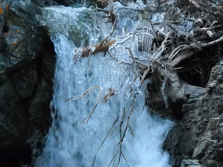
The access road terminates at an abandoned gas well site where are foot paths continue on. Not far along the foot path is a pretty water fall. Another path to the right goes up the slope to a rivulet with a small water fall on it as well. This was about a 2 and a half hour hike for me but I could have spent a lot longer here. If or when I return I will plan to explore Pincher Ridge and perhaps attempt to link up with the trail, shown on my map, below Victoria Peak. I would then make the hike a loop rather than just in and out.
 It is easy to see why the creek was named Drywood Creek. The creek banks are covered with gnarled and twisted fir trees. In places large patches of trees have died leaving twisted trunks and limbs bleached in the sun. As one would expect this gives the valley an edge of uniqueness over other scenic mountain valleys.
The weather was cool, near freezing it seemed, and spring like. A lot of snow remains on the mountains. There was a stiff wind, typical for the region, but the mountain scenery is always exquisite and finding shelter from the wind beside a water fall is rewarding enough to make the hike all worth while. And there are 2 ravens in that valley who with endorse that. Go there. The ravens will welcome you as well.
I ended my hike at 8:24 PM.
Distance: about 9 Km.
Time: 2 hr. 22 min. moving, 32 min. stopped.
Ascent 410 M.
Max elev. 1736 M.
(5694 ft.)


No comments:
Post a Comment