Tuesday, December 22, 2015

Hewing Instead of Hiking

Hewing a Shaving Horse

In January 2014, out here in the Lynx Creek area, a lot of trees blew down so working with an ax, a pruning saw and some other hand held tools I figured I could do a little woodcraft.

By mid March I had found a sold aspen and hewed it down, mostly with an ax, because that is pretty well all I had to work with, to where I could innovate a shaving horse.


 When the time came and I had to leave Lynx Creek I threw the log over the fence , not knowing if I would return for it or not, but I did return and early in January 2015 I retrieved my aspen log and used it again for a month or so. This time my stay at Lynx Creek only lasted until early February. When I left the second time I tossed the log on the wood pile. During a visit in late April or Early May I noticed the log was still there so when I returned in November I came prepared with me a one man crosscut saw and a two man crosscut saw, as well as a bow saw and another bucksaw. I also brought the usual woodworking tools, drawknives, spokeshaves, chisels, planes etc. I had a notion I would complete the project. I also have a clearer idea of how I would proceed. My first task was to hew it down a more level bench area and put legs on it. A birch sapling cut into appropriate lengths made suitable legs.
 Next I would need a good sold piece of wood to make the bottom part of the clamp. I sawed a solid piece of log out of one of the spruce trees which had been blown down almost 2 years ago. 

 First this log would need to be hewn square.


Then I would saw and hew it down to a wedge shape.
 Next I mortised a square hole using a wood chisel.


 Next I mortised a matching hole in the bench part as well.  

 For the upper jaw of the clamp I first tried to get a good piece of aspen and after a lot of sawing by hand I was only to discover the aspen log was rotten in the middle. Then I went in search of a piece of pine. There are lots of dead pine but after chopping and sawing I realized that finding good solid pieces was not so easy.
I only discovered this piece of pine was not suitable after sawing it out of a larger tree and carrying it quite away. It had a lot of wood rot and I had to discard it.

I decided this tree trunk might be solid enough for what I needed to do.

 It took a considerable amount of chopping to free the roots. Once the stump was free I then set to hewing it down enough to allow me to carry it to my work area.                                                              


 It took a lot more sawing and hewing to bring the piece down to size with a the tenon on it.


 Next came the task of fitting and adjusting all the pieces so that the upper jaw would align with the lower jaw. Once it looked like everything would fit it was all tied together using some readirod. A 3/4” bolt is the pivot for the upper jaw of the clamp.

 Last of all a hole is bored in the bottom of the tenon and a foot brace was whittled and inserted.

Now I can begin to shave down this piece of birch. 

 Building a shaving horse with limited tools in this way takes a lot of physical effort, but then a project like this is not as much about the destination as it is about the journey.

Friday, March 28, 2014

The Peace River

I have not been so diligent at keeping this Blog up to date but a recent walk, near Hudson's Hope, BC, has  inspired me to make an entry. There has been enough warm weather recently to settle the snow sufficiently to make walking feasible on most trails now.  This is one of the better walks I have taken. The total distance I walked was about 8 km, but it was the 1 km, more or less, along the high bank of the the Peace River that was most inspiring. There is something about large rivers and Grand valleys which stirs my soul. On this walk my view of the Peace River, framed in it's immense and seemingly timeless valley, has again stirred my passion for such places.


There is a proposal by BC Hydro, currently in progress, to obtain approval to build a hydroelectric dam downstream near the town of Taylor. If Site C is built this river will be changed forever.

Sunday, March 23, 2014

Just Over A Year Ago


March 1, 2013, I hiked the Devil’s Garden trail in the Arches National Park, Utah, with my brother. Started the hike about 10:00 AM and hiked to the Landscape Arch first, then the  Double O Arches, where we met people from Equator. Then we hiked to the Navajo Arch where we met people there from New Mexico. Returned to the van at about 4 PM.
Hiked 9 km in about 4 hours.

March 2, 2013, Today I did a few short walks in the Mesa Verdi, Colorado with my brother. We also took the Cliff Dweller Tour was was only 1.6 km and it took us about 1 hr. and 30 min.

March 4, 2013, first thing this morning I went for a short walk around the Water Canyon Camp Ground, New Mexico.  Next my brother drove to the Large Array Radio Telescopes near Magdalena, NM and my brother and walked around there which took about 1.5 to 2 hours walking estimated 3 – 4 km.

March 5, 2013, I walked around The Alamo historic site, with my brother and then went on the River Walk. My brother said he would take me on the River Walk so I was imagined this would be a long walk through a park. The walk turned out to be not quite what I expected. It was a walk along the river but it is in in Downtown San Antonio and we were walking through malls and outdoor cafes and shops. My brother showed me where he had seen a Bittern, not far from the hotel he had stayed at, on a previous visit to San Antonio. I find it odd that he was a bittern here in an urban area when I have only ever seen them in rather remote marshes. We started the walk at around 7 PM and ended it at around 8 PM. and it was about 3.3 km. 

March 6, 2013, today I walked the beach at Corpus Christie. I started at 09:37 AM and  finished at noon at the Bob Hall Pier. the walk was 5.7 km.1 hr 54 min. This was my second time visiting any ocean and my first walk on the Gulf Coast. What else can I say but amazing. 
In the evening, walked the beach by the Seashore National Park for 1.6 km.

March 7, 2013, Today I bicycled the beach at the Seashore National Park. It is difficult to describe how much I enjoyed this. Just watching the birds and the sea life, ghost crabs and such. Later I stopped for a scheduled beach walk sponcored by the park service. I stared bicycling at about 10 AM and I was back by 12:15 PM and road about 17 km. I observed, Queen butterfly, Laughing Gull, Black Belly Plover, Sanderlings. Later in the day my brother and I rode our bikes on the Beach for another 3 km.

March 8, 2013, today I did a walking tour with my brother around the USS Lexington then we drove over to the Museum Of Art to see replicas of the ships the Pinta and Santa Maria.

March 9, 2013, today my brother and I drove over to Bird Island. I walked along the shore for about 2.3 Km.
When I got back to the National Sea Shore I played in the surf . In the evening I went for a walk with my brother we saw an Earless Lizard, Portuguese Man Of War,  and a crippled Crab. We walked the beach until we came to a Blade width road cut through the sand dunes. We wound up walking through the Park Administration and then we walked back on the paved road. We stopped for awhile and visited with some people by a pond with hundreds of ducks on it. I probably walked a total of 7.1 km today.

March 10, 2013,my brother and I visited the Aransas Wildlife Refuge.  we observed Cattle Egret, Turtles, a Carriage  Whip Snake, alligators, a big frog or toad, another unidentified snake and best of all 2 Whooping Cranes. This is the first time I have ever seen a Whooping Crane.  I did a walk by myself and my brother and I did a few short walks. 

March 17, 2013, I normally do not go into caves but I was persuaded to take the tour of the Inner Space Caverns near Austin, Texas. This is about a 3.2 km walk and it is all underground. We observed an Eastern Pipistrelle Bat.
This is the furthest I have ever gone underground and likely the furthest I ever will go. 

March 19, 2013,  my brother and I camped at Lake Mineral Wells State Park, so in the evening I took a bicycle ride in the park . My bike chain was so badly rusted from riding it in the Seaside Park  I had to get oil off the dipstick of the van and oil yje chain before I could ride my bicycle. I road about 7 km in 43 min.

March 25, 2013, My brother and I visited the did Petrified Forest, Arizona and we took the short walks, one walk was about 1.2 km. The that afternoon round 2 PM my brother and I took the tour of the Impact Crater which is a walk on the rim of the crater. 

March 26, 2013,  today I walked some of the south rim of the Grand Canyon, with my brother.

March 27, 2013, my brother and I walked the Watchman in Zion's Park, Utah.

March 28, 2013, I went for a bicycle ride in Rexburg.

March 31, 2013, Easter, I started out just before noon from a place in West Lethbridge and hiked into the river valley and then up to the U of L. I checked a Geocache that I had found last year and found it is in need of maintenance. Then I went looking for Crocus and Buffalo Bean but found none. I observed Mallards and Goldeneye ducks and perhaps a Canvas back. They were all in pairs. The gulls are back. My goal was to walk 10 miles but I was a little short of that as I only walked about 15.5 km. 


Friday, August 30, 2013

Still Catching Up On My Posts

February 2013

February 2, 2013, walked in and around Cardston, with my brother and also solo.
I started at the house and walked to my brother's house. We walked east of his place, then south, then west, then north back to his house.
6.6 km with . In about 1 hr. 30 min.
MapMyHike: 10.7 km in 2 hrs. 20 min. which would mean to and from the house was 4.1 km. in about 50 min.

February 6, 2013, Ski North Wabasca Lake, solo.
Started from Wabasca between 4 and 4:30 PM, skied on the lake to Fisherman’s Wharf. Walked from the house across the road then skied down the bank to the lake. Skied mostly on latent snowmobile tracks. When I got to Fishermans Wharf I found ski tracks but it was time to turn back so I determined I would try them out tomorrow. Returned at 5:45 PM.
GPS: 5.3 km. 
Time: 1 hr. 15 min. moving.
Elev. 1842 ft.
MapMyHike: 5.88 km. in 1 hr. 30 min. 

February 7, 2013, Ski North Wabasca Lake, solo.
Started from the same place between 10 and 10:30 AM. I was able to follow yesterday’s track most of the way to Fisherman’s Wharf. On my way there it seemed like there was a fresh snowmobile track over my ski track but on the way back I found my ski track from yesterday. At Fisherman’s Wharf I followed a ski track around the 2.8 km triangle. I took a break and then went around again the other way. I returned to the house at a little after 2 PM.
GPS: 10.6 km.
3 hours 20 min. moving, 30 min stopped.
Max elevation 1899 ft.
MapMyHike: To Fisherman’s Wharf plus the loop clockwise, 5.71 km in 1 hour 51 min.
MapMyHike: The loop counter clockwise and back from Fisherman’s Wharf, 5.27 km. in 1 hr. 27 min. 
Total =   10.98 km. in 3 hrs 19 min.

February 8, 2013, Skated with my granddaughter.
MapMyHike: 2.56 km in 30 min.

February 9, 2013, skied the Mini Birkie. Start Time was at 1:30 PM.
Skied 13.3 km in 2 hrs. 10 min. stopped time was 12 min.
Ascent 751 ft. max. elev. 2546 ft.

February 10, 2013, walked in Tofield, likely with my sister and her husband.
MapMyHike: 1.75 km in 21 min.

February 11, 2013, skied Campbell’s Lake with my sister.
Started at around 10:30 AM. And finished at around noon.
6.45 Km. 1 hr. 29 min. moving time, 20 min stopped time.

February 12, 2013, skied Campbell’s Lake with my sister and her friends. Started at about 10:30 AM and finished at well before noon. My sister kept up a brisk pace this time.
6.29 Km.
1 hr. 3 min. moving time, 3 min stopped time.
Moving average was 6 km/hr. which is a fast pace for me.

February 13, 2013, ski Muriel Lake Municipal Park with my sister. We started at around 11:30 AM and finished at around 2 PM. Temperatures were around 0°C and there was a light covering of fresh snow so we had a problem with the snow sticking to our skis.
9.15 km but 8.4 km might be a more accurate measurement.
2 hr. 14 min. moving time, 34 min. stopped time.
Ascent 477 ft, max. elev. 1957 ft.

February 14, 2013, ski Campbell’s Lake with my sister. Started at around 10 AM and finished at just after 11 AM. There was a fresh snow cover on a well groomed track so conditions were ideal.
6.09 Km.
1 hr. 3 min moving, 11 min. stopped.
We can’t seem to break the 6 km/hr speed.

February 15, 2013, Skate in Cherry Grove with my sister.
MapMyHike: 2.24 km in 1 hour 25 min. 

February 17, 2013, hike Johnson Canyon in Banff National Park with my nephew. Started at around 12:30 PM and finished at about 3 PM.
6 km in about 2 hours.

February 22, 2013, walk in Cardston from the Cardston house to my brother's. 
MapMyHike: 1.55 Km. in 20 min.

Then walk with my brother.
MapMyHike: 7.3 km in 1 hour 56 min.

February 24, 2013, ski Akamina Pass and to within 300 M of Wahl Lake, solo. Started at around 11 AM and finished at about 3:30 pm.
13.2 km
3 hr. 44 min moving, 47 min. stopped.
Ascent 1306 ft., max elev. 5963 ft.

February 27, 2013, walk in Rexburg, solo. Started around 8:30n AM and finished at 10 AM. 
6.6 km.
1 hr. 25 min moving, 15 min. stopped.

February 28, 2013, hiked with my brother in the Arches National Park in Utah. We hiked to the Delicate Arch and back. Then without realizing it we hiked to a view point of the Delicate Arch.
Total hiking 7.9 km.

Total Km walked, hiked and skied in February was 102 km.

Thursday, August 29, 2013

Where Oh Where Has The Foot Loose Been?

Whether anyone has noticed or not I have not made a Blog entry since early January. The truth is I would rather be in motion than entering text at a keyboard. That said, truth is a Blog is not a Blog unless I make some sort of entry. I keep notes of most of my walks, hiking, bicycling and paddling so what you will get here are my raw notes. At least you, the follower, will know that I am out and about and sooner or later I will again treat you to a titillating account of my treasured adventures.

January 2013


January 5, 2013, hike at Police Outpost Park, solo (mostly). 
I started out at about 3:30 Saturday afternoon, the park is closed so I had to park my vehicle at the park gate and walk in. It is only a few hundred  metres to get to the trail which goes to the International Border. I walked the trail to the Canada-US boundary and I found things have changed a little since I was there about a year ago. The fence style where people could walk through to look at the boundary marker now has a barbed wire fence through it. I muttered things about the absurdity of the 49th parallel and climbed the fence anyway. I snapped a couple of photos then hopped back over the fence to my own country. Then for some reason I decided not to walk the path back. Instead I walked west along the boundary fence down to the Outpost Wetland. I had started to walk on a frozen pond going back toward my vehicle when I heard something so I looked around but saw nothing so I kept going. Then I heard someone shout and I turned and saw a person and a dog. He motioned to me to hold up so I thought, "I could be in trouble". I started walking toward the guy so he soon caught up with me. Sure
enough he was US border patrol. He had a few questions about where I came from and which way I was heading. I was more puzzled by where he came from because I had not seen a vehicle or a fresh track at all. The border guy said they have caught people smuggling guns at this place. Sheeze I  sure don't want to bump into any gun runners. It seemed like I was out in quiet solitude but I guess not. So I chatted about my other hikes in the area and seeing a helicopter on patrol when I hiked that way in 2005. He was pretty courteous and listened to my stories. Then I hoofed it back to my van. I got some nice photos of Chief Mountain. When I got to my van there was a black 4X4 with tinted windows which seemed to be lurking around while I made notes about the hike. I found it very mysterious and of course after talking to the border patrol every vehicle I see around there is a gun runner.

5.09 km.,
1 hour 21 min. moving, 23 min. stopped.
Ascent 387 ft
Max. Elev. 4751 ft.

January 6, 2013, ski Cameron Lake, solo.
Started at around 10:30 AM, skied to Cameron Lake, then to Akamina Lake and back, then to the Akamina Pass Trail Head. At Cameron Lake I spoke with a guy and 2 ladies who were out skiing. I realized I had met the guy while skiing at Cameron Lake a couple of years before. He was the guy who was talking to Demitre the first time I ever met him. It turns out this fellow works with some of the same people I worked with in Public Lands. I had a good chat with him, as we skied to the Akamina Pass Trailhead. Then I skied over the Akamina Pass to where my grandson and I camped last summer. At the pass I met 5 or 6 snowshoers. On the way to the camp I met 3 ladies on skis. Skied on to the Forum Falls, met the ladies again coming back from Forum Falls. Took photos of the falls. The falls are frozen and much subdued compared to their summer flow. The snow deadens all sound giving the place the quiet ambiance of a temple. The snow conditions were weird, in that, a little fresh snow was falling and it would stick to the bottom of my skies like wet snow would. Skiing down from the pass is always an easy fun glide. Met the snowshoers again just past the bridge. I tried to stop gracefully but I fell instead. Visited a bit the finished my glide to the Cameron Lake road then took the old road back to parking. At Forum Falls I was starting to feel tired and by the time I got to my vehicle at about 3:30 PM I was tired.
12.8 km., in 3 hours 53 min. moving, 1 hr. stopped.
Ascent 1224 ft.
Max. Elev. 5954 ft.

January 8, 2013, walk  in W Lethbridge, solo.
Walked to the store and back from my daughter's.
MapMyHike; 2.69 km., in 1 hour 11 min.

January 12, 2013, ski in Cardston, with my brother.
Started at my brother's place and skied down to Lee Creek. Skied along Lee Creek to past the Hwy 2 bridge. There was water on top of the ice in several places and the ice popped and crackled but it seemed solid enough. Past the bridge we ascended the bank and skied beside the walking trail. The walking trail already had the snow ploughed off. Then skied back down the bank to Lee Creek and under the 9th Ave. bridge, then back up the creek bank and along the trail by the Golf Course. Saw one Flicker, maybe a fox and as always Magpies. Skied until about 2:10 PM and then returned the same way. Finished at about 3 PM
MapMyHike: 5.13 KM. in 1 hour, 42 min.

January 13, 2013, ski Cameron Lake, solo.
By the time I arrived at about 10 AM the parking lot was already mostly full. It wasn’t as wind on this day as it was on last Sunday. Started skiing a little after 10 AM. Skied to Cameron Lake and noticed tracks, maybe snowshoe, going toward the east shore so I followed them for about 400 M then I lost the track so I turned toward the east shore and skied around in the trees. Large blowdown and a creek so at about 11:45 I skied back to the lake and back to where the trail follows the west shore. Followed a track along the east shore to the end of the trees. On my way I met 3 skiers returning. Talked to 3 snowshoers at the trees. Followed some tracks up into the trees which turned out to be tracks the alpine skiers made when coming down. Stopped for lunch at about 12:30 then skied back to the lake and back to my vehicle. Saw a Stellar’s Jay and a Gray Jay. Not much for tracks, just squirrels.
Returned to my vehicle at about 2 PM.
10.7 km. in 3 hr. 4 min. moving and 45 min stopped.
Ascent 421 ft. Max Elevation 5555 ft. 

Total Distance under my own power 41.19 – 3.5 = 37.69 km. 

January 15, 2013, walk in Tofield, with Matty the dog.
MapMyHike 3.07 km in 57 min.

January 18, 2013, walk from Rundle Park to Hermitage Park and back, solo.
Because of warm temperatures and rain conditions for skiing were not the best and the ice on the Rundle Park Pond was closed so the only thing left to do was to go for a walk. I started sometime after 3 PM at the pond in Rundle Park and walked to the of leash area in Hermitage Park and back to Rundle Park. I was back at Rundle Park a little after 5 PM.
10.3 km
2 hr. 19 min. moving, 3 min. stopped.
338 ft ascent, max elev. 2133 ft.
MapMyHike: 10.61 km. in 2 hr. 20 min.

January 22, 2013, cross-country skied around Campbell’s Lake with my sister and my cousin.
Started a little after 10 AM at the Hamilton House B&B and skied clockwise around the lake. Heard a Pileated Woodpecker.
MapMyHike: 6.91 km. in 1 hr. 30 min.

January 23, 2013, walked from house in Cardston to the Extra Foods and back, solo.
It was so cold my romaine lettuce got frozen.
Started at about 4 PM and finished at about 5:30 PM
MapMyHike: 5.3 km. in 1 hr. 24 min.

January 29, 2013, walk from the house in Cardston to the Superstore and back, solo.
MapMyHike 5.31 km in 1 hour 24 min.

January 30, 2013, ski/hike to Lower Bertha Falls with my brother.
We started out on the Bertha Lake trail at about 10 AM on our skis but I broke a binding so we continued on to the falls by hiking. Returned to the vehicle by about 1:30 PM.
MapMy Hike: I didn’t start MapMyHike until my binding broke, 5.99 km. in 3 hr 9 min.
On the GPS, which was started at the vehicle: 6.3 km.
2 hours 33 min. moving, 1 hour stopped.
Ascent 737 ft. Max elev. 4782 ft.
At 4:30 PM walked to Ken’s and back around 8 PM.
MapMyHike: 6.44 km. in 50 min.

Total distance recorded walking and skiing in January is 84.86 km. 
Tuesday, January 15, 2013

Beachs and Boundaries

January 4, 2013

I was in Cardston, Alberta for a few days, I had been busy inside for the morning but by noon I wanted to get outside, for a ski or a walk, before the day ended. I have visited the St. Mary’s Reservoir during the spring and summer But I had not visited it in the winter. Wally's Beach on the St. Mary's Reservoir is less than an hour drive from Cardston so it was a good place to drive to for an afternoon outing.
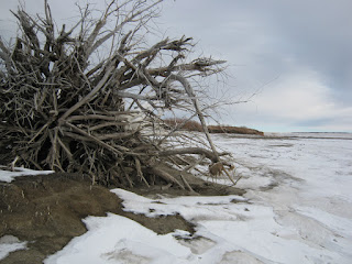
By about 1 PM I had arrived at the gate to Wally’s Beach. The gate is closed during the off season so I parked there and walked the road to the beach. There were latent tracks in the last bit of snow where a Cross-country skier had gone but the snow was now rapidly melting away and skiing was not possible.  As I walked south on the beach I realized the reservoir is frozen and I could likely walk out to a nearby island and do some exploring there. At a narrow place between the beach and the island, I set out across the ice and I soon arrived at the shore of the island. The water levels in the reservoir fluctuate seasonally which causes the banks to be constantly eroded.
These photographs are of an entire Cottonwood tree which has eroded from the bank, root and all, and has now drifted onto the beach.                            The entire walk around the island was 3.2 km. and I did it in about 1 hour.
I then walked back across the ice to the beach and back to my vehicle the same way I came.
The total distance I walked was 8 km., in about 2 hr. and 50 minutes.


January 5, 2013,

 It was January 14, 2012 when I first visited Police Outpost Park in the winter (refer to my Blog, Setting Boundaries). 
The park is close to vehicles so I parked at the locked gate and started my walk into the park at about 3:30 PM on this Saturday afternoon. It is only about 600 M to get to the trail which goes to the International Border. I was undecided as to which way I should walk, but I decided I would like some photos of the sunset at the Canada-US border marker so I walked the trail to the Canada-US boundary. I found things have changed a little since I was there about a year ago.
Last year a person could squeeze through a stile in the fence and walk over to the boundary marker. Now there is a
barbed wire fence right through the stile. I assumed the fence was to discourage visitors from going any further. Upon seeing this I muttered a few things about the absurdity of the 49th parallel and climbed the fence anyway. I snapped a couple of photos and then hopped back over the fence to my own country. Next, for some reason I decided not to walk the path back but instead I walked west along the boundary fence toward the Outpost Wetland. In about 200 M the boundary fence jogs south several metres and the fence clearly shows less maintenance. Then, as I continued on to the wetland, the fence eventually is just laying on the ground. As I am walking I have more thoughts about how absurd a boundary is which does not at least follow the natural geographical features.
I arrived at the frozen wetland and once I determined the the ice was be safe to walk on I started back toward where my vehicle was. I had not walked far on the ice when I heard something but I could not determine what. Think it might be a bird or an animal call I stopped and looked around but saw nothing so I kept going. Then I heard someone shout and I turned and saw a person and a dog. I think I faintly heard the person shout that he wanted to talk to me and motioned to me to hold up so I thought, "I could be in trouble". I started walking toward the guy so he soon caught up with me and as he approached me I could see he was in some sort of uniform. Sure enough he was US border patrol. He asked where I came from and which way I was heading. I was more puzzled by where he came from because I had not seen a vehicle or a fresh track at all. Once he established that I was a Canadian on my way back to my vehicle and I was just out for a walk he seemed satisfied with that information. Then we chatted a bit. The border guy said because there is a road nearby in Montana which is close to the road in Alberta they have caught people smuggling guns across the border at this place. Sheeze! It seemed to me I was out in quiet solitude with no one else around and now  I might to bump into gun runners!
I chatted with be border patrol guy about my other hikes in the area and about seeing a helicopter on patrol when I hiked that way in 2005. He was pretty courteous and listened to my stories. Then we parted ways and I hoofed it back to my van. On the way back I watched the sunset and I took photos of the wetland in the winter with Chief Mountain in the background.
When I got to back my van and as I was making notes about my hike there was a black 4X4 pickup truck with tinted windows which drove by a little slower than what I thought was normal. Then it drove by again and then seemed to be lurking around all while I made my notes about the hike. The suspicious movements of this vehicle cast an air of mystery upon the whole situation and of course, after talking to the border patrol,  every vehicle I see here is carrying a gunrunner.

Saturday, January 12, 2013

Out With The Old


December 31, 2012,
What better way is there to finish off the year 2012 than to get out and do something active. The morning of December 31, 2012, I was in Tofield so it was natural for me to choose to ski in the Cooking Lake Recreational Area. I started at around 9:00 AM from the Islet Lake staging area, skied the Lost Lake Trail to the west end of Elk Push Lake then I returned on the Push Lake trail back to the Lost Lake trail and back to the parking lot. I finished my ski at around 10:30 AM.

When I first visited Islet Lake I my thoughts were, "this is place must be a well kept secret" because it seemed to have all of the serenity and beauty of Elk Island National Park without the people. As time has past I believe I notice more people are using the area. Currently there are no user fees for using this area so I am not surprised if, in fact, there is an increase in visitors.

As I arrived at the Staging Area there were a few cars in the parking lot, all skiers I think, but, on my ski I was only over taken by one pair of skiers, so, even though there were other people on the trails I was still favored with ample solitude during my ski. As I negotiated the undulating terrain through the poplar woods, interspersed with birch groves and white spruce, I was in familiar territory but still feeling the thrill and adventure of the days activity.


During my ski back, on the Lost lake Trail, I particularly enjoyed the view of Islet Lake cloaked in a blanket of snow. Winter has its way of subduing the landscape which deepens the solitude one will find there.

 During this outing I skied about 6.5 km. in about 1 hr. 27 minutes.