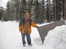
Dec. 19, 2011, Trekking Pole Try Out. Walked solo from William Hawrelak Park east along the south river breaks to the Whitemud Freeway bridge and back.
While hiking to Raven Lake and Grizzly Den back in October, and on previous hikes as well, my brother brought Trekking Poles. Before he got the trekking poles this he often used a walking stick or staff. I have usually resisted using a walking stick. Some of my reasons why I have resisted are because I am forgetful and so often leave my walking stick somewhere or I forget to bring it, I have also found that a walking stick can be a great asset on some terrain but in other situations it can quickly become a liability. On a few hikes now I have borrowed one of my brother’s trekking poles, usually to descend steep and difficult sections of the trail and I have to recognize that a trekking pole clearly gives any hiker greater stability. A staff or a walking stick also aids whit stability but what I came to realize is that the retractable trekking poles can be collapsed and put away in a backpack when they are not needed thus eliminating the nuisance of having to carry them when you are not needing to use them. This one feature alone convinced me to make trekking poles a part of my hiking equipment.
Today I bought trekking poles at MEC. I bought Komperdell poles because they were marked down to $66. That seemed like a bargain so how could I resist. This afternoon I went on a hike to try them out. I started at William Hawrelak Park and I hiked the east and south river breaks to the Whitemud Freeway bridge where I crossed to the north river breaks and returned from west along the river. As I there is variety in the terrain on this walk it was a good choice. I met a guy carrying a camera and with an impressive telephoto lens. I stopped to chat with him and in the course of our conversation I learned about the types of woodpeckers that frequent these areas and I heard the word leucism, reduced pigmentation particularly in birds, for the first time, or not that I recall at least.
I noted many signs or portions of this route warning of dangers and to stay off the trail but there were lots of foot prints going where the signs said not too so I followed the people tracks on through these posted areas. On my return walk I ended up in the off leash area so I encountered many dogs. One or two dogs seemed mildly intimidated by the trekking poles.
For the most part the trekking poles worked out well.
Distance walked about 10 km.
Moving time 2 hr. 35 min. stopped time 18 min.
total acsent 536. max elev 2338
Thursday, December 29, 2011

Ice Walking
Dec. 17, 2011, I walked on Islet Lake with my nephew Dave.
We started out for the Central Staging in the Cooking Lake Recreation Area, but I missed a turn and we ended up at Islet Lake anyway. The first place we walked was over to the lake to check it out and we decided to walk over to the main island. We explored the large island some of the smaller islands. We observed one interesting ice heave between an Island and a point of land. The ice on the lake appeared to be 1 foot thick. There were areas with no snow cover and areas with no snow cover. Walking on the snow covered areas was quite easy but the clear areas were slippery so we barely averaged 2 km/hr. I fell down once.
Distance walked was 4 km
Moving time 1 hour 45 min.

Dec. 18, 2011, Walked Mill Creek in Edmonton with a friend.
We started out at 93 st. and 69 ave. Walked around the south side of the residence in the ravine bottom (89th Ave.) at about N53 30 46.8 W113 28 18.1. Along the trail there was a tree that had been chopped down. On our return we took a little different route and missed the tree so we back tracked to it so we could salvage some twigs off of it. On the way back we found Christmas ball ornaments hung in the trees and took photos.
Total distance 9.3 km
Total time about 2 to 2.5 hours
We started out for the Central Staging in the Cooking Lake Recreation Area, but I missed a turn and we ended up at Islet Lake anyway. The first place we walked was over to the lake to check it out and we decided to walk over to the main island. We explored the large island some of the smaller islands. We observed one interesting ice heave between an Island and a point of land. The ice on the lake appeared to be 1 foot thick. There were areas with no snow cover and areas with no snow cover. Walking on the snow covered areas was quite easy but the clear areas were slippery so we barely averaged 2 km/hr. I fell down once.
Distance walked was 4 km
Moving time 1 hour 45 min.

Dec. 18, 2011, Walked Mill Creek in Edmonton with a friend.
We started out at 93 st. and 69 ave. Walked around the south side of the residence in the ravine bottom (89th Ave.) at about N53 30 46.8 W113 28 18.1. Along the trail there was a tree that had been chopped down. On our return we took a little different route and missed the tree so we back tracked to it so we could salvage some twigs off of it. On the way back we found Christmas ball ornaments hung in the trees and took photos.
Total distance 9.3 km
Total time about 2 to 2.5 hours
Monday, December 26, 2011
Back at Kakamina
Dec. 10, 2011, Cross country ski with my Grandson. Waterton National Park.
When I am on an outing like this I like to use my light weight stove as much as possible. I feel that if I use this piece of equipment often then I am able to ensure it is in good working order. When we were finished the activity I fired up my stove and melted snow and made Hot Chocolate and heated up a package of dried chicken soup. This turned out to be a good way to warm up at the end of a very successful outing.
Total distance covered, 4.5 km
Cold Lake Provincial Park North
December 7, 2011, Solo Walk in Cold Lake Provincial Park, North side of Cold Lake.
This is not new territory to me but it seems like new territory since most of my memories of this area are from the summer of 1974. I had a summer job with Alberta Fish and Wildlife and I traveled this area. Back then the area was vacant land and not part of a provincial park. I am not sure when it was made a provincial park but I believe that this could be my first visit to the area since it was made a park. I was not expecting to be walking in a park. The approach where I turned off the Primrose Highway, where I started my walk, was pretty much as I remembered it. The first 700 m was on a limited use road which apparently has a lot of 4 wheel drive, ATV, and snowmobile traffic but then there is a vehicle barricade and I continued my walk in the park on and old vehicle trail. I walked for about for 600 m and then I left the trail. I had a notion to walk as far as I could toward the Martineau River and through the bush was the most direct route. I found it still fairly easy walking. In 1.5 km at around 2 pm I intersected another old vehicle track. I decided to take a break and that this was a good place to turn back. There was a very light dusting of new snow so conditions were good for identifying tracks. There were the usual tracks of Red Squirrel and small rodents. There were a number of fresh deer tracks and coyotes. I also found 2 or 3 sets of grouse tracks. After I turned back I saw a Pine Grosbeak. After I turned back I followed the trail and found that this trail is maintained by the park personnel, nevertheless there were a few new blow down trees on the trail. The trees posed no obstacle to me on foot but they might to a cyclist or skier. I stayed on this trail to walking west for 2.3 km. This trail appears to be the main route through this part of the park. My GPS map showed another trail going generally north and I had chosen this as my route back to my vehicle. This trail is entirely over grown with trees. There are the distinct marks where vehicle ruts were worn into ground but there are now what appear to me to be 30 year old spruce trees growing in the ruts. The trail is not discernible at all in the area of an old beaver dam. If I had not been following a feature outlined on my GPS map then I would have likely lost it altogether, but with the aid of my GPS I was able to stay on the old track and there were the occasional discernible vehicle ruts to verify that there had indeed been a trail there at one time. It was curious to me that in one place there were mostly spruce trees growing in the old trail while aspen was the predominate cover every where else. Clearly the old trail had been seeded to spruce trees or there was some aspect of the vehicle travel on the trail which promoted the germination of White Spruce trees. I followed this over grown trail 1.7 km. back to my vehicle. It was about -10 C with a stiff wind but once I got into the shelter of the trees and as long as I was walking the temperatures were quite tolerable.
7.2 km
2 hours 30 min moving.
43 min stopped.
Max elevation 1968 feet.
Thursday, December 15, 2011

October 17, to 21, 2011, hiked to Raven Lake Cabin and Grizzly Den Cabin.
I did this hike with my brother. The cabins were originally built and maintained by the Son's Of Norway but they are now maintained by BC Parks. The cabins can not be reserved so it is first come first serve and share and share a like. Both cabins are equipped with a stove and fire wood is provided. There are not many other amenities so bring mattresses and camp cooking equipment. Even without a tent my backpack weighted close to 50 pounds.
To get to the cabins turn south off highway 16 onto the Hungary Creek forestry road. At the start Jim made a good decision by parking at the Grizzly Den trail head and we started our hike by walking on the forestry road back to the Raven Lake trail head. The weather was unsettled and there was a threat of showers but when we hiked out 5 days later it was a steady rain and it was nice not to have to hike the extra 2.6 km to the vehicle.
The hike to the Raven Lake cabin is 5.5 km. with an elevation gain of about 1500 ft. At about 5000 ft there was a complete snow cover. It rained some as well so by the time we got to the cabin we were wet from precipitation and perspiration. the snow also made the rocks on the trail very slippery. I found the hike to be rather taxing.
That evening we were having supper and Jim noticed a couple of mice running across the floor of the cabin. He had brought snap traps to the cabin earlier that summer but had taken them on to the Grizzly Den cabin so there were no traps. He then built a figure 4 trap but he couldn't get it to work right. I suggested using a bucket with a baited stick. We caught one mouse that night and another one the next day in the bucket. The next day Jim got the figure 4 trap working and we caught one mouse that evening and another one in the night. That took care of the mouse problem.
October 18 we hiked up on Raven Peak. This day was the sunniest day of all and a good day to hike to the peak even though it was a bit windy. That hike was about 4.6 km. On the way down we noticed another peak to the northwest and we planned to hike that one the next day.
October 19 the day started with a steady rain but around noon the rain let up and so we set out. As we started up the slope to the peak a fog set in. When we got to the peak it was so foggy that we weren't sure where we were but there was a stone cairn so we guessed it marked the peak. We saw 2 ptarmigan at the peak. They were in pure white plumage. We wanted to go down a different route but it was hard to pick a route in the fog then the fog cleared some and we were able to easily make our way down. This was about a 4 km hike.
October 20, we hiked from Raven Lake cabin to Grizzly Den cabin. There was a bit of fresh snow so it was interesting to see fresh animal and bird tracks in the snow. Fresh snow really shows what has been in the area that day. Most of the tracks were red squirrel's but we also saw weasel and possibly marten tracks. The snow on the trail was mostly ankle deep but out on the open slope it had drifted a little deeper. Jim broke trail most of the way so when we were ascending up Pat's Pass I offered to break trail for awhile. I started out in the lead but I soon sopped for a rest. Then I found I had to rest again. I was finding breaking trail was not so easy. Finally Jim said, "let me take it to the top of the pass" and away he went. When he was breaking trail I could just about keep up. At the top of Pat's Pass we dropped our packs and hiked up the the peak. The weather cleared enough for us to see the Raven Lake Peak and the surrounding area. It was a very grand view and well worth the hike up. We made it to Grizzly Den cabin in good time that day. It was about a 5.4 km. hike.
Oct. 21, 2011, we hiked back out to the vehicle from Grizzly Den Cabin.
6.5 km out
2 hr 19 min moving
36 min stopped
Max elev. 5731
As I mentioned earlier it was raining steady by the time we got out and I was rather wet. We did take time to check out some Caribou tracks that we noticed on the way out.
By my calculations we hiked 25.25 km. in total on this trip.
Oct. 22, 2011, Hiked with Jim in Forests For The World Park.
This is a park within the city of Prince George, BC and it has a lot of variety with uplands and low lands and some scenic water bodies. Pack a lunch and take your time if you go there.
About a 9 km hike.
Total ascent 972
Max elev. 2952
3hr moving
52 min stopped
2245 ft max elev.
October 30, 2011, Walked solo in the JJ Collette Natural Area.
Observed spruce trees gnawed by a porcupine and a porcupine burrow. I was surprised to see trees gnawed by a porcupine as the bark has so much resin.
7.24 km.
2 hr 15 min. moving.
21 min stopped
Total ascent 528 ft.
Max. Elev. 2955
Later in the day I met a friend in Red Deer and went for another short walk in Three Mile Island Park.
4 km.
My daily total walking was 11 km.
November 16, 2011, I walked with my sister around Campbells Lake in NE Alberta.
8.5 km.
November 24, 2011, Walked solo in Hawreluk Park
3 km
November 27, 2011, I went for a walk with a Meetup Group.
We started at Terwilligar Park and walked to the Anthony Henday Bridge and a little beyond. 9.5 km.
December 1, 2011, I went for a walk with a Meetup group in the Edmonton River Valley. We started at the Royal Glenora Club and walked to the Legislature Building to look at the Christmas lights. We then walked on the north side of the river to the foot bridge and then back on the south side of the river and across the LRT bridge.
This was a fairly brisk walk of about 8 km.
1 hour 48 min moving.
December 5, 2011, I walked with a friend in Mill Creek.
About 7 km and we walked about 2 hours.
Fall Walks
Oct. 5, 2011, Walk Demarias to Wabasca;Not every walk has to be an adventure. I would call this a utilitarian walk. I was dropped off at the grocery store and I walked most of the way back. The 4.5 km/hr pace I kept might be slightly faster than usual because of the dogs nipping at my heels.
5.8 km, 1 hr 17 min. Level walking on sidewalk averaged 4.5 km/hour.
Oct. 6, 2011 Somewhere West of Demarias.
Bill is a fellow I met in Demarias through a mutual friend. He is a hunter so he was hunting and was kind enough to let me tag along. This walk was along cut-lines and access roads.
6.8 km.
October 7, 2011, Canoe North Wabasca Lake.
I was hoping for clear sky and gentle breezes. I got a stiff breeze and a failed attempt to canoe to the Willow River on N. Wabasca Lake. I started out in what seemed to be calm but when I got to the point the wind picked up. I started to paddle across across the bay anyway but the breeze stiffened. I made it to the shelter of the point where the old channel of Willow River is and decided the wind was too strong and so it is in my best interest to get started back toward the point where I had launched. Fortunately I was going with the wind, generally. Paddling a canoe solo into a wind like that makes the canoe difficult if not impossible to control. The canoe rode the waves well but it took steady exertion to work against the wind and keep the canoe off the rocky shore. I did notice a lone swan flying over the lake and there are always eagles to be seen by this lake.
4 km, 1 hr.
Oct. 9, 2011, Walk In the Downtown Edmonton river valley.
I took this walk in the afternoon with a friend. It was a clear and warm day. There were still fall colors and even a few boats on the river.
Oct. 16, 2011, hike Mount Robson View Point trail.
While walking in the shadow of the majesty of Mount Robson how could I not be moved to write something.

1 hr. 9 min. moving, 14 min stopped.
Total ascent 427 ft.
Max elev. 2999.
5.8 km, 1 hr 17 min. Level walking on sidewalk averaged 4.5 km/hour.
Oct. 6, 2011 Somewhere West of Demarias.
Bill is a fellow I met in Demarias through a mutual friend. He is a hunter so he was hunting and was kind enough to let me tag along. This walk was along cut-lines and access roads.
6.8 km.
October 7, 2011, Canoe North Wabasca Lake.
I was hoping for clear sky and gentle breezes. I got a stiff breeze and a failed attempt to canoe to the Willow River on N. Wabasca Lake. I started out in what seemed to be calm but when I got to the point the wind picked up. I started to paddle across across the bay anyway but the breeze stiffened. I made it to the shelter of the point where the old channel of Willow River is and decided the wind was too strong and so it is in my best interest to get started back toward the point where I had launched. Fortunately I was going with the wind, generally. Paddling a canoe solo into a wind like that makes the canoe difficult if not impossible to control. The canoe rode the waves well but it took steady exertion to work against the wind and keep the canoe off the rocky shore. I did notice a lone swan flying over the lake and there are always eagles to be seen by this lake.
4 km, 1 hr.
Oct. 9, 2011, Walk In the Downtown Edmonton river valley.
I took this walk in the afternoon with a friend. It was a clear and warm day. There were still fall colors and even a few boats on the river.
11.3 km,
2 hours 56 min moving.
20 minute stopped.
526 total ascent.
2384 ft. Max. elev.
Oct. 10, 2011, An urban bicycle ride.
I rode one way from West Edmonton to South Edmonton.
14.9 km,
1 hour 8 min moving.
5 min stopped.
Total ascent 372 ft.
Max elevation 2386 ft.Oct. 16, 2011, hike Mount Robson View Point trail.

While walking in the shadow of the majesty of Mount Robson how could I not be moved to write something.

"The streets of heaven are paved with gold - this is what I'm told. If it is so, then I have walked them this very day. I followed a path where a golden cloak of freshly fallen autumn leaves were lain chivalrously for me. I much preferred the path I trod today to one of shimmering gold. For leaves lain with hue and pattern in sun beam's shimmer seem so much more than gold."
Solo. 6.69 km,
1 hr 43 min moving. 58 min stopped.
Total ascent 1328 ft. Max . Elev. 4069. Left at 7:20 am returned at 10:00 am.
Later the same day I stopped and walked to Rear Guard Falls.
Solo 782 m,
17 min moving, 3 min stopped.
Total ascent 139 ft.
Then I did a contemplative and reflective walk in the Ancient Forest. Several trees have fallen on the pathway. Seem to be rather recently.
Solo 2.66 km,1 hr. 9 min. moving, 14 min stopped.
Total ascent 427 ft.
Max elev. 2999.
Monday, November 28, 2011
Fall Hikes and Walks
I haven't made an entry here since September 1, 2011. This year it was my intent to keep a log of how far I have traveled under my own power, meaning walking, skating, skiing and paddling. I have done pretty well. I think I had a notion that I wanted to go about 500 miles this year but I am not going to make that. I am very close to having logged 500 km this year. Not an amazing distance by any stretch but still not so bad. In fact this total doesn't include every walk or bike ride that I have taken this year. I have even done some paddling that didn't get noted, but this Blog is not about statistics. What I really want to do here is guide the reader to take a walk, or paddle, or bicycle as often as possible.

I have now hiked many if not all of the trails in Elk Island Park. In August I was camping in Elk Island National Park and as I was driving north from the Sandy Lake Campsite toward Lamont I noticed the sign for the Beaver Pond Trail. I had not hiked that trail before so on August 23, I hiked the 3.68 km trail with a friend of mine. August is a time when plants are maturing and fruits are forming. The insect population had subsided a bit making walks a lot more tolerable. There were many interesting types of mushrooms along the trail.
On August 30 I did a short but interesting walk in the Blackfoot Recreational area. I only walked about 2.2 km but a lot of the way was through bush and not on the trail. I came upon some bones. By the size and length of the bones I guess they were moose but they could have also been elk. If I had found the skull then I would have known for sure but there was no skull.
While fishing at Mink Lake with my daughter and her partner on Sept. 7, 2011 I paddled around
We hiked 9.9 km, 4 hrs 47 min moving and 2 hrs 55 min. stopped, our total ascent was 3276 ft. and our maximum elevation was 7138 ft.
On August 30 I did a short but interesting walk in the Blackfoot Recreational area. I only walked about 2.2 km but a lot of the way was through bush and not on the trail. I came upon some bones. By the size and length of the bones I guess they were moose but they could have also been elk. If I had found the skull then I would have known for sure but there was no skull.
On Sept. 2, I did a short walk in the Wagner Natural Area.
2.17 km
On Sept. 4, Walked with a friend in the Clifford E. Lee Wildlife Preserve.
2 km.
33 min.
Waterfowl were in their fall plumage so they are impossible to identify. Well almost so, the Shoveler's bill is very distinctive. It was good to see standing water in many more areas this year although the water is still a long way from the board walk and judging by the size of the trees encroaching onto the boardwalk it has been this low for many years.
While fishing at Mink Lake with my daughter and her partner on Sept. 7, 2011 I paddled around
Mink Lake solo in my canoe.
4.6 km.
Elevation 2460'
On and around the lake there was a Bald Eagle, many ducks in fall plumage, Killdeer, terns flying over head, Great Blue Heron, beaver, and sand pipers. I caught a fish.
September 13, 2011, My brothers and I did a hike to a small cabin near Ozilinka Mountain called the Ozilinka Hut. The hut is maintained by some folks who live just outside of McBride, BC and it can be reserved and rented. The hut has a wood burning heater, a 3 burner propane cook-stove, pots and pans and foam mattresses so there is no need to carry a tent, a camp mattress or a camp stove and dishes. The hike to the cabin is just over 6 km and it took us about 5 hours to get there. The total ascent is 1489 ft. and the maximum elevation is 5757 ft. We arrived at the Hut at about 3:53 pm. We noticed some bear poop on trail and 1 bear track in trail further along. It was a calm evening and fair weather.
On Sept. 14, the three of us did a day hike to Phalarope Lake and Ozilinka Lake.We hiked 9.9 km, 4 hrs 47 min moving and 2 hrs 55 min. stopped, our total ascent was 3276 ft. and our maximum elevation was 7138 ft.
There are entries in the log book of people hiking to the summit so we looked for a route to the summit but it all looked too rugged for us to try. I think this is the highest elevation I have obtained this year so far. Many flowers. Marmot tracks. 1 dead lemming.
That evening we checked the maps in the Hut and found another lake. So the next day, September 15, 2011 we hiked to Fan Lake. We hiked about 10 km, our total ascent was 2435 ft., and the maximum elev. was 6891 ft. We found fur and a jaw bone of a lemming which appeared to have been preyed on by a falcon. the fur was removed in small pieces. There is lots of Lemming poop in piles. We found a nice waterfall on the way back. A thunder shower caught us on the way back so we got wet and it was nice to have a warm and dry place to go to.
On September 16, 2011 we did a day hike to Clyde Pass.
7.8 km, and we were gone about 5 hrs. Total ascent 2082 ft. Max elev. 6447 ft. We observed several Lemmings dead and decayed. The trail to the pass had been cleared and flagged just the day before we went so it was easy to find and follow. After Clyde Pass we did a side trip to where Jim, Doran and I thought the pass was last year. We left just after noon and arrived back by 5 pm. A very pleasant day.
September, 17, 2011, Hiked out. Started at 8;30 AM and arrive at the vehicle at 11:57 just over 3 hours out.
Great Beaver Lake, BC
I urged a my brother Jim to rent me a kayak and take me on a trip so on September 18, 2011, he took me to Kayak on the Great Beaver Lake. We left from the Forestry Campsite on Great Beaver Lake, BC at about 3:45 pm. Our departure was delayed somewhat because as I was entering the kayak I tipped it and I got rather wet. Fortunately it was a reasonably warm afternoon and paddling kept me warm until I was able to dry out. We paddled 8.54 km, in about 2 hrs 3 min. We saw an Eagle , and fish jumping like porpoises. We arrived at camp at 6:10 pm.
September, 19, 2011. We stayed in camp all morning. I whittled a walking stick out of Aspen. After lunch we went for a paddle across the lake to a place where Jim had camped twice before. We saw an Eagle, waterfowl, we heard a heard moose ( Jim saw the moose and said there were 2). We also may have seen an osprey. We paddled 9.8 km. in less than 3 hours. We were b ack at camp about 5 pm.
September 21, 2011 we paddled back 8.62 km in about 2 hours.
Subscribe to:
Posts (Atom)