November 29, 2012,
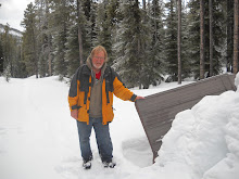
On my drive from Prince George BC to Edmonton I decided to stay over at the Tete Jaune Lodge in Tete Jaune Cache, BC (http://www.tetejaunelodge.com/). I wanted to do a some skiing or a hike the next day before continuing on to Edmonton. My last hike in Robson Park was on July 2, 2012. I have driven through the park on other trips but I have never stopped to do a hike. I was pleased to find the road up to the Berg Lake trail head had the snow plowed so I proceed to the trail head. At the trail head I find someone has skied the trail the day before so there was a ski track set. It wasn't long until I was on the ski track with a goal of skiing as far as Kinney Lake.
What a contrast between skiing on this day and hiking the trail on July 2, 2011. Today my vehicle was the only one in the parking lot and I was the sole occupant of the trail, compare that to a full parking and the hussel and bussel I had encountered in July, 2011. The sounds of the traffic on Highway 16 reached me as I started my ski but even that was soon gone. The trail to Kinney Lake follows the Robson River and sound of water tumbling and cascading over rocks soon drowned out any sounds of the outside technological world. The trail starts out in the BC Interior Rainforest as I ski among mature Red Ceders. As the trail increases in elevation the Douglas Fir become the dominant tree cover. The trail leaves the river for a while and the world I am in takes on a primal silence.
In about an hour and a half I reach Kinney Lake in a landscape now cloaked in snow. Most of the lake is covered with ice. The white cloak on the landscape subdues the greenery of summer and everything, trees, mountains and sky, have become the shades of gray. The air is calm and some open water, where the river exits the lake, is like a mirror reflecting the distant mountains.
For quiet and solitude could there be a better place than this, or a better time. I linger for about half an hour and then start back. Since I had a rather early start I expect, for sure, I will meet someone on the trail as I ski out, but it is just me today, me and a few latent tracks of snowshoe hare, caribou and a cougar.
The ski out is quick and fun. All of the elevation I gained during my ski in is now being 'burned off' with long glides. I am exhilarated by the quick pace but it seems I am back at my vehicle too soon. I am still the only person in the parking lot.
Monday, December 3, 2012
Saturday, November 3, 2012
Tracking a Grzzly
October 24, 2012, Grizzly Bears still roam in the mountains in the snow. At least that is what my brother Ken and I observed on our hike over the Akamina Pass and into to Forum Falls.
We
started out our hike on this day at the barricade on the Cameron Lake road in about 5 inches of fresh snow and as we got into the upper elevations the snow depth was closer to a foot. The freshly fallen snow provided perfect
conditions for studying animal tracks. My brother and I find great interest and
satisfaction in interpreting the tracks we find. Mostly it is speculation as to
what made the track and when they were made. As we got close to the top of the Akamina Pass we encountered a new set of tracks coming out of the trees and onto the trail. We had no trouble identifying them as Grizzly Bear tracks.
As for me I had confidence that since the bear was heading steadily away from us it had little concern with our presents. If this bear was digging or had been feeding I would have left the area the way I came.
Seeing Forum Falls
subdued by it’s encasement of fall ice and snow was a pleasant scene.
When we reached the Akamina Pass trail head decided to hike over to Cameron Lake. At Cameron Lake we observed some water fowl on the lake. There is a Nuttal’s
Cottontail Rabbit living around the information buildings. Next we walked the trail to Akamina Lake and observed a Dipper working the shore
where Cameron Creek exits the lake. The Dipper is a curious site as it walks in and out of the frigid water, it regularly completely submerges itself as it forages for submerged aquatic insects.
On the hike back we took the trail through
the trees instead of the road. More drama was apparent on this trail where the track of a
fox and a Snowshoe Hare meet and the gate of the hare clearly changes to great
leaps and continues that way until it takes an abrupt turn and vanishes into
the underbrush.
I can walk for hours in the woods and never see a thing but when walking after a fresh snow fall the tracks in the snow give me proof there is an abundances of activities happening by the creatures who make this place their home. Ample reason for me to tread lightly and be a respectful guest of my unseen hosts.
Total distance = about 11 km. in about 5 hours 15 minutes.
Ascent was about 729 ft, max. elevation 5953 ft.
Thursday, October 25, 2012
The Leprechaun Trail
Oct. 13, 2012, I am in the interior of British Columbia staying in a ski hut at a place called Grizzly Den with my 2 older brothers. The day before yesterday we drove the Hungry Creek forestry road to the trail head and then hiked the 6.5 km into the hut. Yesterday was a snow day but by today the snow had stopped falling and much of the snow on the ground was already melting.
Just by a wet
meadow on the Grizzly Den trail a Rough Legged hawk silently swooped by
and perched in a near by evergreen tree. As the three of us were observing the hawk a Merlin swooped in, dove at the Rough Legged hawk and drove it from its perch. As the larger Rough Legged Hawk retreated the smaller and much more maneuverable Merlin gave chase and they soon disappeared from view down the slope and across the meadow. In moments both birds reappeared from the direction they had gone, the Merlin still tenaciously pursuing the larger, less maneuverable Rough Legged. They swooped back past
us and disappeared up the trail into the woods. As we proceeded on our way down the trail we speculated about what would provoke an attack on the larger by a smaller bird but we were not able to come to any solid conclusions. The best we could come up with was the Merlin was defending its territory.
Several hundred metres down the trail we flushed a grouse off the trail and into a tree. We know there are three species of grouse in this area the Ruff grouse, Blue grouse and the Spruce grouse. I am reasonably sure this was a Blue Grouse.
The Leprechaun trail is a steady hike up through evergreen woods. Much of yesterday' s snow was gone as there was no snow below about 5000 feet. As we hiked up the trail and we got back into some snow. Hiking in fresh snow facilitates the chance to observe what has and is happening in the woods and who or what resides there. As we moved along the trail we observed tracks of squirrel, marten, grouse and weasel. I noticed a burrow with tracks in and out. Maybe a Martin. Is this where it lives or was it just checking it out as part of it's hunt for food?
Several hundred metres down the trail we flushed a grouse off the trail and into a tree. We know there are three species of grouse in this area the Ruff grouse, Blue grouse and the Spruce grouse. I am reasonably sure this was a Blue Grouse.
The Leprechaun trail is a steady hike up through evergreen woods. Much of yesterday' s snow was gone as there was no snow below about 5000 feet. As we hiked up the trail and we got back into some snow. Hiking in fresh snow facilitates the chance to observe what has and is happening in the woods and who or what resides there. As we moved along the trail we observed tracks of squirrel, marten, grouse and weasel. I noticed a burrow with tracks in and out. Maybe a Martin. Is this where it lives or was it just checking it out as part of it's hunt for food?
The Leprechaun ridge and the peak were windy but afforded us a grand view. The descent of the peak is steep and rugged but it isn't far down to Pat's Pass. We had some lunch in the shelter
of trees then hiked up to Pat's Peak and another great view.
By mid afternoon we were back at the hut with good memories of a very satisfying hike.
The total hike was 7.21 km over about 5 hours.
Total ascent 2055 feet.
Maximum elevation 6169 feet.
For more information about where the Grizzly Den and Raven Lake trails are and how to get there go to: http://www.trailpeak.com/trail-Raven-Lake-near-Prince-George-BC-2741
Monday, October 1, 2012
Rattlers and Rivers
On September 21, 2012 I drove to Writing On Stone Provincial Park to camp out with my Grandson. That evening we attended a park program about the night sky. During the program the audience received the requisite cautions about potential encounters with the Prairie Rattle Snake. This is the time of year when rattlers are on the move back to their hibernaculum. Also because of the cooler evenings snakes are attracted to warm areas, like pavement or rocks, in the morning so they can warm themselves up. As it turns out the Parks Person doing the presentation was proven absolutely right the following day.
On September 22, 2012,
while my grandson was reading his book, I went for a bicycle ride.I started out at about 9:30 AM
I rode from our campsite up to the Park view point. I parked my bicycle at the trail to the view point and walked the short way up to the view point. What a great time of year it was to visit the park and see river valley in fall colors. I lingered there awhile and as I proceeded back along the gravel path I saw a very small rattle snake just in front of me. This snake would have been hatched this summer so it was rather small but I am told even small Rattlers have venom and should be treated with respect. When I first spied the snake it was relaxed and basking in the warm morning sun but as I rummaged through my pack and fiddled with my camera I clearly disturbed it and it coiled. I only tarried there long enough to snap a few photos and then I carefully stepped around the snake, watching closely for any others that might be near by, and left it to further enjoy basking in the sun.
No trip to Writing On Stone is complete unless you scramble around in the Hoodoos some, so that afternoon Levi and I spend about 3 hours exploring the Hoodoos. Levi even tried to catch a bush. For some humor in the hoodoos check out this link:
http://www.youtube.com/watch?v=5ggzgDx28ZI&feature=share
Before leaving I tied my canoe on top of my van so I could paddle across the Milk River. I wanted to be sure I could take a walk on the south side of the river. Once I was at the park I discovered there was barely enough water in the river to float a canoe. On September 23, 2012,
I waded across the river and then put on my hiking boots and did a 3.84 km walk in the back-country hiking area. I started around 8 AM
and I followed a Track File, I had loaded on my GPS, of a hike I did in May 2007. I observed a few Mule Deer in the river and as I walked a small canyon I observed a Rock Wren. This back-country hiking area is a quiet and little used part of the park, a great lace to reflect and take in more of the park's fall grandeur. I returned to our campsite at around 9:30 AM.
| Fall colors in the Milk River Valley, from the south side looking north. |
My total distance recorded for the Writing On Stone camp out is 11.6 km, by bicycle and walking.
Friday, September 14, 2012
You Know You Are Having a Good Summer When....
You know you are having a good summer when you spend a lot of time being active and but not much time at the key board making Blog entries. The disadvantage of this is that now I have a long list of activities and experiences and a short time to get them all down. As I reflect back on my summer here are some of the highlights.
According to my notes I hiked the Bears Hump in Waterton National Park on June 29. I did it with my daughter's family, and my grandson. I was surprised with how strident my twin 5 year old granddaughters were at hiking up the trail. I look forward to many more hikes with them.
If you like small furry 4 legged creatures who are friendly then go to the top of Bear's Hump and ply the golden-mantled ground squirrel's friendship with nuts. Oh but I better add that feeding the wild animals in a national park is frowned upon.
Then on June 30, I was paddling my canoe with a friend on Islet Lake in the Cooking Lake Recreational Area. My I do get around.
Clearly a highlight of my summer was paddling the west arm of Myrtle Lake, BC with my brother and his grandson from July 2 to July 7. I now consider myself experienced as a kayak tripper.
On July 4, the three of us hiked up Central Mountain. The Central Mountain trail is rough at best but offers a great view of the Kostal Cone, a volcanic cone that erupted about 3000 years ago. We hiked until we encountered snow and that was as high as we wanted to go.
My notes from July 5, 2012 read:
Paddled the kayak past Leo island and then along, and into, every bay on the south shore of the lake. I came to a sign that says Hellset (a couple of days later I asked the park guy aboutthis sign. He said there used to be a trail to Hellset Lake but it is no longermaintained). Hellset is the last name of the guy who once had a cabin on thisbay.
An Osprey flew rightover me.
There was thunderin the south then it showered so I decided to return to camp. Left Hellset at 11:50 AM and got back to camp at 12:44PM. Less than 1 hour becauseof the threat of lightning and then near Leo Island a steady rain started.
On a rock south of Leo Island I observed a Barrows Goldeneye and a Common Merganser sitting on the same rock completely unconcerned with me as I silently glided by. Clearly scenes like this are why paddling is such a pleasure for me.
According to my notes I hiked the Bears Hump in Waterton National Park on June 29. I did it with my daughter's family, and my grandson. I was surprised with how strident my twin 5 year old granddaughters were at hiking up the trail. I look forward to many more hikes with them.
If you like small furry 4 legged creatures who are friendly then go to the top of Bear's Hump and ply the golden-mantled ground squirrel's friendship with nuts. Oh but I better add that feeding the wild animals in a national park is frowned upon.
Then on June 30, I was paddling my canoe with a friend on Islet Lake in the Cooking Lake Recreational Area. My I do get around.
Clearly a highlight of my summer was paddling the west arm of Myrtle Lake, BC with my brother and his grandson from July 2 to July 7. I now consider myself experienced as a kayak tripper.
On July 4, the three of us hiked up Central Mountain. The Central Mountain trail is rough at best but offers a great view of the Kostal Cone, a volcanic cone that erupted about 3000 years ago. We hiked until we encountered snow and that was as high as we wanted to go.
My notes from July 5, 2012 read:
Paddled the kayak past Leo island and then along, and into, every bay on the south shore of the lake. I came to a sign that says Hellset (a couple of days later I asked the park guy aboutthis sign. He said there used to be a trail to Hellset Lake but it is no longermaintained). Hellset is the last name of the guy who once had a cabin on thisbay.
An Osprey flew rightover me.
There was thunderin the south then it showered so I decided to return to camp. Left Hellset at 11:50 AM and got back to camp at 12:44PM. Less than 1 hour becauseof the threat of lightning and then near Leo Island a steady rain started.
On a rock south of Leo Island I observed a Barrows Goldeneye and a Common Merganser sitting on the same rock completely unconcerned with me as I silently glided by. Clearly scenes like this are why paddling is such a pleasure for me.
Wednesday, July 25, 2012
Crash Sites and Forest Fires
June 9, 2012, hike in the York Creek area, near Coleman, Alberta, to the 1946 crash site by Mount Ptolemy and Ironstone Lookout, solo:
"On January 19, 1946, a Royal Canadian Air Force DC-3 (Dakota) left Comox, British Columbia on a flight to Greenwood, Nova Scotia. It never arrived and its crew of seven were reported missing. It took five days for the Crowsnest Pass Forest Rangers to snowshoe to the crash site because of bad weather. They were guided by the smoke of the burning plane. There were no survivors, the rescue team brought the bodies out on toboggans. The men who lost their lives were: Flying Officer Robert Huycke Watt, Flying Officer James Leonard Norris, Flight Lieutenant William Joesph Woods, Flight Lieutenant William James Sealy, Sergeant Vernon Rupert Ducklow, Leading Aircraftsman Daniel Levy and Leading Aircraftsman Richard Brockwell Lowe."
http://www.waymarking.com/waymarks/WM114_Dakota_Plane_Crash_1946
The aircraft apparently struck Mount Ptolemy and crashed near the headwaters of North York creek. I had been told about this crash site a couple of decades ago and I have intended to hike there ever since. Reading a description of the hike in Joey Ambrosi's Southern Rockies Trail Guide was the motivation I needed to finally attempt the hike.
I parked my vehicle along the forestry road on the north side of the bridge that crosses York Creek. I started my hike from there at just a little after 6 AM. There is some signage and with Ambrosi's trail description I was able to find the route. The hike is mostly on forestry roads and 4X4 and All Terrain Vehicle (ATV) trails. At about 1700 M long stretches of the trail still had snow. The snow was packed and solid enough to walk on so it did not hinder me much. At about 9 AM at 1900 M elevation I broke out of the trees to find the Cirque, where the crash site is, completely snow covered. I had intended to visit the crash site and then explore the alpine meadows and the ridge above it but I have no experience hiking in snow and the evidence of avalanche damage in the area discouraged me from venturing further. Once I left the shelter of the trees I found myself exposed to a stiff wind which was driving a light snow fall through the evergreens. I turned back down the trail and at about 9:15 AM, back in the trees and sheltered from the wind, I took a break.
Since I had planned to spend the day exploring the alpine meadows and possibly climbing the ridge behind the crash site I now had the time to take a more leisurely back and time to take a few photographs. While hiking up the trail I had noticed some bear scat but it appeared to be weeks old so I had little concern about encountering a bear. Also just before the place where the trail branches off to the Ironstone Lookout trail I heard, then came upon, 2 guys on trail bikes. The wideness of the trail and the ruckus that the ATVs and Trail Bikes made had me relaxed about encountering bears or any wildlife during my hike.
As I was hiking back I remembered the Trail Guide described a second hike up to the Ironstone Lookout on the Willoughby Ridge. I decided to at least hike to the start of that trail and determine where it is at. Once I arrived at the trail to the Ironstone Ridge I used my GPS Map to conclude that the summit was less than a kilometer away. It was not noon yet and I reckoned that I could hike up to the ridge in less than an hour and take a break for lunch when I got there.
Over 2 km, because of some long switchbacks, and an hour and a half later and I was on the ridge. At about 1900 M elevation I was encountering a lot of snow on the trail. The weather was still unsettled but the day was warming up and now the snow was softening and making it not as easy to walk on. In spite of feeling tired by this time, and knowing that I now faced at least a 6 km hike back to my vehicle, this was still an awesome hike. The Trail Guide describes the area like this, "Ironstone Lookout, perched on the crest of Willoughby Ridge, presents the determined hikers with a sweeping 360 degree panorama of the Crowsnest region and a dramatic overlook onto the extensive burn of the Lost Creek Fire". The Lost Creek Fire happened in July 2003 and burned about 22,000 hectares.
Once on the ridge there are two directions I could have gone. To the left was a communications tower about a kilometer away and to the right was a forestry Lookout. As I got to the ridge I was on a complete snow cover again and to walk to the Forestry Lookout I would be walking in deep drifted snow. There were no obvious tracks on the trail indicating to me that I had been the first to venture that far. I was also cognizant that I had already hiked about 17 km and it would still be a 6 km hike back to my vehicle. I decided to hike a little way up the ridge until I was at 2000 M elevation and take a much needed break. The sweeping view of the Crowsnest region made every step well worth the effort.
The access to the Ironstone Lookout is a 4 wheel drive road but it has a gate so there was no ATV traffic on that trail when I walked it. I found some fresh bear scat along the trail and one possible bear print. There were also numerous ungulate foot prints on the trail. The most striking part of the whole trail were the wild flowers. The Glacier Lily and Calypso Orchids were in bloom everywhere.
As I walked the road up to the ridge I found this written in permanent marker on an old painted plank,
“In times of loneliness, who did you turn to? It was the fire. When your world came crashing down around your shoulders with hardship and pain, who stilled your grief? It was the sun. When the stern face of storms plagued you, who was there to give you shelter? It was the spruce and fir with their backs for cover and their scents of comfort. When trauma and confusion stole your spirit and spilled Hope to the ground, who woke in your dawn ....?(this part is weathered away)?.... joy to your heart? It was the singing birds, the funny squirrels, the jumping fish, and the majestic caribou. When authorities controlled your life and were displeased, who returned solace and comfort? It was the eternal hymn from beautiful mountains and silent woods.” "Stan Walchuk Jr. Cordillera"
Given the time and place I was in when I read this I was profoundly moved by it, to say the least. I later Googled Stan Walchuk and found out that he traveled, by himself with two horses, from Alberta to Alaska through the Rocky Mountains. Cordillera is the title of the book he wrote about that journey. In a small way then I feel akin to him as I often am a lone hiker on a small journey of my own.
About 9 hours and about 24 km after I started out that morning I was back at my vehicle.
"On January 19, 1946, a Royal Canadian Air Force DC-3 (Dakota) left Comox, British Columbia on a flight to Greenwood, Nova Scotia. It never arrived and its crew of seven were reported missing. It took five days for the Crowsnest Pass Forest Rangers to snowshoe to the crash site because of bad weather. They were guided by the smoke of the burning plane. There were no survivors, the rescue team brought the bodies out on toboggans. The men who lost their lives were: Flying Officer Robert Huycke Watt, Flying Officer James Leonard Norris, Flight Lieutenant William Joesph Woods, Flight Lieutenant William James Sealy, Sergeant Vernon Rupert Ducklow, Leading Aircraftsman Daniel Levy and Leading Aircraftsman Richard Brockwell Lowe."
http://www.waymarking.com/waymarks/WM114_Dakota_Plane_Crash_1946
The aircraft apparently struck Mount Ptolemy and crashed near the headwaters of North York creek. I had been told about this crash site a couple of decades ago and I have intended to hike there ever since. Reading a description of the hike in Joey Ambrosi's Southern Rockies Trail Guide was the motivation I needed to finally attempt the hike.
I parked my vehicle along the forestry road on the north side of the bridge that crosses York Creek. I started my hike from there at just a little after 6 AM. There is some signage and with Ambrosi's trail description I was able to find the route. The hike is mostly on forestry roads and 4X4 and All Terrain Vehicle (ATV) trails. At about 1700 M long stretches of the trail still had snow. The snow was packed and solid enough to walk on so it did not hinder me much. At about 9 AM at 1900 M elevation I broke out of the trees to find the Cirque, where the crash site is, completely snow covered. I had intended to visit the crash site and then explore the alpine meadows and the ridge above it but I have no experience hiking in snow and the evidence of avalanche damage in the area discouraged me from venturing further. Once I left the shelter of the trees I found myself exposed to a stiff wind which was driving a light snow fall through the evergreens. I turned back down the trail and at about 9:15 AM, back in the trees and sheltered from the wind, I took a break.
Since I had planned to spend the day exploring the alpine meadows and possibly climbing the ridge behind the crash site I now had the time to take a more leisurely back and time to take a few photographs. While hiking up the trail I had noticed some bear scat but it appeared to be weeks old so I had little concern about encountering a bear. Also just before the place where the trail branches off to the Ironstone Lookout trail I heard, then came upon, 2 guys on trail bikes. The wideness of the trail and the ruckus that the ATVs and Trail Bikes made had me relaxed about encountering bears or any wildlife during my hike.
As I was hiking back I remembered the Trail Guide described a second hike up to the Ironstone Lookout on the Willoughby Ridge. I decided to at least hike to the start of that trail and determine where it is at. Once I arrived at the trail to the Ironstone Ridge I used my GPS Map to conclude that the summit was less than a kilometer away. It was not noon yet and I reckoned that I could hike up to the ridge in less than an hour and take a break for lunch when I got there.
Over 2 km, because of some long switchbacks, and an hour and a half later and I was on the ridge. At about 1900 M elevation I was encountering a lot of snow on the trail. The weather was still unsettled but the day was warming up and now the snow was softening and making it not as easy to walk on. In spite of feeling tired by this time, and knowing that I now faced at least a 6 km hike back to my vehicle, this was still an awesome hike. The Trail Guide describes the area like this, "Ironstone Lookout, perched on the crest of Willoughby Ridge, presents the determined hikers with a sweeping 360 degree panorama of the Crowsnest region and a dramatic overlook onto the extensive burn of the Lost Creek Fire". The Lost Creek Fire happened in July 2003 and burned about 22,000 hectares.
Once on the ridge there are two directions I could have gone. To the left was a communications tower about a kilometer away and to the right was a forestry Lookout. As I got to the ridge I was on a complete snow cover again and to walk to the Forestry Lookout I would be walking in deep drifted snow. There were no obvious tracks on the trail indicating to me that I had been the first to venture that far. I was also cognizant that I had already hiked about 17 km and it would still be a 6 km hike back to my vehicle. I decided to hike a little way up the ridge until I was at 2000 M elevation and take a much needed break. The sweeping view of the Crowsnest region made every step well worth the effort.
As I walked the road up to the ridge I found this written in permanent marker on an old painted plank,
“In times of loneliness, who did you turn to? It was the fire. When your world came crashing down around your shoulders with hardship and pain, who stilled your grief? It was the sun. When the stern face of storms plagued you, who was there to give you shelter? It was the spruce and fir with their backs for cover and their scents of comfort. When trauma and confusion stole your spirit and spilled Hope to the ground, who woke in your dawn ....?(this part is weathered away)?.... joy to your heart? It was the singing birds, the funny squirrels, the jumping fish, and the majestic caribou. When authorities controlled your life and were displeased, who returned solace and comfort? It was the eternal hymn from beautiful mountains and silent woods.” "Stan Walchuk Jr. Cordillera"
Given the time and place I was in when I read this I was profoundly moved by it, to say the least. I later Googled Stan Walchuk and found out that he traveled, by himself with two horses, from Alberta to Alaska through the Rocky Mountains. Cordillera is the title of the book he wrote about that journey. In a small way then I feel akin to him as I often am a lone hiker on a small journey of my own.
About 9 hours and about 24 km after I started out that morning I was back at my vehicle.
Thursday, June 14, 2012
Boats and Bears
May 27, 2012,
canoe Touchwood Lake
with my brother-in-law.
I believe this was the first time I had my old gruman canoe in the water this year and this is my first camp out of the year as well. It was might good to get out for a paddle.
Because
the breezes were light, the sky was clear, the weather conditions appeared
stable, and the lake was calm we set our course from the boat launch directly across the bay for the
point of land jutting out from the west shore. Once we reached the point we held to the
shore line on a southerly course. About halfway along the point we heard and
then saw an Osprey. The Osprey appears to have a nest in a high tree at this
place. We proceeded along the shoreline for as long as we could. There a good
‘fair weather’ campsite on the southern end of the point. From the southern tip of the point we picked the
closest shoreline on the east shore and paddled directly for it. By this
time a light wind had picked up and it produced low swells, which our loaded
canoe easily navigated.
The east shoreline tracks almost due south so we were able to hug the
shore line all the way to the Seibert Lake Trail Head. Along this shore Tony
spotted two Whitetailed deer. We also noticed surveyor’s ribbon in 2 places but
we couldn’t determine what, if anything, they were marking. We arrived at the
trail head at about 12:30 PM. The landing at the Seibert Lake Trail Head
has limited space for boats and there is a half metre berm to lift the canoe over in order to beach it. This required that we unload the canoe with it still in the water so wear your rubber boots or be prepared to get your feet wet.
Distance
= 12.6 Km.
Time
= 2 hours 45 min. moving and 11 min stopped.
After
lunch and a rest we did an afternoon walk to explore the trail over to Seibert
Lake at about 300 M
down the trail is a Trapper’s Cabin. The trail is maintained and seems to be
used mostly by ATV quads. The trail would accommodate a canoe or kayak cart quite
well which presents a possibility of portaging a boat to Seibert Lake and doing an extended trip. Seibert Lake
has a long sandy beach. We walked north along the beach to where a rivulet
flows into the lake. As we walked back to the trail we observed a Whitetailed
Deer. The deer was quite a way south on the beach when I first saw it, but as we crouched and watched it moved
closer to us. It was very twitchy and would graze and then move a bit further
toward us. Eventually it bounded off into the woods. We then walked directly back
to Touchwood Lake.
Total
distance = 6.5 Km.
Total
time = 1 hour 46 min. moving and 30 min stopped.
After
supper we paddled the canoe along the south end of the lake to the out flow of Touchwood Lake. We were only able to paddle down the out flow for about 100 metres before we came to a beaver dam. We saw a couple of
beavers.
Distance
= 2.6 Km.
Time
= 47 min.
May 28, 2012, just
as we were about to depart from our camp site we were doing one last walk
through when my brother in law noticed a Black Bear on the trail. I held the dog while it
barked and growled but the bear did not back off. Then Tony we
moved toward the boat. As we moved away the bear advanced. The bear went to
where we had kept our food and did our cooking. Then it moved to the site of the
campfire and next it went over to the tent area. I prefer encounters with bears where the bears run away.
We
left the campsite to the bear at about 9 AM.
The lake was perfectly calm so we paddled directly across the south end of the
lake to the west shore. We held to the west shore as we paddled north until the large point of land
came into view. Then we set our course directly for the point. While we were
canoeing the west shore we saw the osprey fly by. I also noted the location for
the trail to Dabbs Lake.
We stopped at the campsite on the point at about 11
AM. There is a small beach at this campsite which makes it an easy place to land a boat. The site has a table, a bear cache and a
biffy. Once we were around the point we held to the shore until the boat launch
came into view and then we set our course directly for the boat launch. A light wind had
picked up. The wind was mostly at our back so it helped us along. It produced a
modest swell on the lake but it was easily navigated by our canoe. We made the
boat launch area by about noon.
Distance
= 14 Km.
Time
= 3 hours moving, and 20 min stopped.
The
total distance traveled for this trip was 36.4 Km.
Subscribe to:
Posts (Atom)