Saturday, May 19, 2012

Drywood Creek, wind, water, earth.


May 10, 2012, hike Drywood Creek, solo.

On March 25, 2012 I set out to hike Drywood Creek but I was reluctant to continue because of snow on the road.
This is hike #29 in Ambrosi’s Southern Rockies Trail Guide.
On this day I returned to Pincher Creek and even though I drove there, that morning, through a snow storm I still wanted to complete this hike. By late afternoon the snow was gone but it was a cool windy day with a threat of rain showers.
To get to the trail I followed the directions given in Ambrosi’s Southern Rockies Trail Guide. During my drive to Pincher Creek there was a radio news cast about the Grizzly Bears coming out of hibernation and killing sheep in the Castlegar area. This reminded me that I would be hiking in bear country and that the bears will have just come out of hibernation. I admit the information made me a little nervous and I did walk with more vigilance than usual. As it turned out the only critter I saw with fir was a glimpse of what was likely a vole.  I started hiking at about 5:30 PM. Most of this hike was on a graded gravel access road constructed by a gas company. I found Ambrosi's description of the trail to be not entirely accurate but the discrepancies are minor. He mentions 2 culverts to cross Drywood Creek but in fact there is only one culvert. The important thing is that there were no creeks to cross and my feet stayed dry. At 1.6 km on the trail there is a culvert, but it is not to cross Drywood Creek, it is only to cross a tributary into Drywood Creek. At 2 km there is a culvert on Drywood Creek.
The access road terminates at an abandoned gas well site where are foot paths continue on. Not far along the foot path is a pretty water fall. Another path to the right goes up the slope to a rivulet with a small water fall on it as well. This was about a 2 and a half hour hike for me but I could have spent a lot longer here. If or when I return I will plan to explore Pincher Ridge and perhaps attempt to link up with the trail, shown on my map, below Victoria Peak. I would then make the hike a loop rather than just in and out.
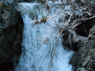
It is easy to see why the creek was named Drywood Creek. The creek banks are covered with gnarled and twisted fir trees. In places large patches of trees have died leaving twisted trunks and limbs bleached in the sun. As one would expect this gives the valley an edge of uniqueness over other scenic mountain valleys.
The weather was cool, near freezing it seemed, and spring like. A lot of snow remains on the mountains. There was a stiff wind, typical for the region, but the mountain scenery is always exquisite and finding shelter from the wind beside a water fall is rewarding enough to make the hike all worth while. And there are 2 ravens in that valley who with endorse that. Go there. The ravens will welcome you as well.
I ended my hike at 8:24 PM.
 
Distance: about 9 Km.
Time: 2 hr. 22 min. moving, 32 min. stopped.
Ascent 410 M. Max elev. 1736 M. (5694 ft.)
Thursday, May 10, 2012

Outpost Wetlands Natural Area

April 28, 2012, walk Outpost Wetlands Natural Area, solo.

When I visited Police Outpost Park last January 14 the Outpost Wetlands Natural Area were of interest to me and I concluded that I must return to the area in the spring. Since the area is posted as being closed to public access from May 1 to July 31 I had to visit it soon or wait until the summer. My main objective on this visit was just to observe and peacefully enjoy what the wetland has to offer. As it turns out I was well rewarded for making the effort.
I started my walk at about 11:30 AM. Since my main objective of this walk was to make observations in the Wetland it wasn’t a strenuous walk at all. I had no sooner started my walk and I discovered Early Cinquefoil in bloom. 
 A settlers log house remains on the grassland in view of Chief Mountain.

 At the edge of the wet land just beyond the old building I paused for a moment and heard Sandhill Cranes very close. As I scanned the margin of the wetland with my binoculars a pair of sandhill cranes came walking out of the grass less than 50 metres away from me. I sat still as they walked past me. Seeing the cranes would have been enough to 'make my day', but as I wandered along the edge of the wetland I also saw Ring Necked-Ducks, Buffleheads, Hooded Mergansers, Trumpeter swans, and Cinnamon Teal. There were also warblers in the willows and a mountain bluebird perched on it's nesting box. In the distance were two eagles one being chased by the other. A Northern Harrier flew low over the marsh as a Redtail Hawk did lazing circles in the sky above me. Skillfully catching some the thermals as the sun warmed the earth below.
I located a Geocache in the Police Outpost Park and as I paused there to have my lunch I watched a moose grazing on the sedges at the far edge of the wetland.
I returned to my vehicle at about 4 PM well satisfied with my day. I went to a campsite to warm some soup and relax a bit. As I relaxed I could hear, in the distance, a Ruff Grouse drumming, a Common Snip winnowing, and the Boreal Chorus Frogs. All of the familiar sounds of  spring.

Distance: 5.98 (Measured it at 6 km)
Time: 2 hours 21 min. moving, 1 Hour 38 min. stopped.
Ascent: 176 M, Max elev. 1451 M

Sunday, May 6, 2012

Birds Eye Butte or Old Guy's Mountain?

April 27, 2012, hike Birdseye Butte with my brother.

When my brother and I set out we did not have a clear idea of where we were going. We ended up on the Chief Mountain Highway in the east side of Waterton National Park. I had my topographical map of Waterton Park and I was checking trails and landmarks as my brother drove. We found that the highway on the east side of the Blood Reserve was barricaded so we were not able to explore any of the trails beyond there. On our way that far a butte had caught our attention and I checked the name on my map. It was Birdseye Butte. After we turned back at the barricade we decided to hike up Birdseye Butte.
Since Birdseye Butte is outside of the park boundary there is no marked trail. We first looked for a trail at the, near by, park picnic site along the highway but found no trail there, so we drove a little further west to where there seemed to be an old road. We did not really find a road or a trail but we found the walking was fairly easy. When we got a gate in the barbed wire fence at the park boundary we found a bit of a trail but we soon lost that trail again. However it wasn't long until we came across a well used vehicle trail which took us up the butte.
The day before this hike my brother became a great grandfather, and I read an article in National Geographic about Gerlinde Kaltenbunner's ascent of K2 without oxygen: http://events.nationalgeographic.com/events/speakers/2013/03/14/k2-la/
As my brother and I hiked up the trail and the slope steepened I joked that we were climbing the butte without oxygen. We stopped for lunch on top of the butte.
I found an elk antler, we saw 2 whitetailed deer and a flock of blue birds. I photographed crocus and prairie shooting stars. On the way back down we noticed deer and bovine bones in the area of the dam. On the way back we went around the west side of the lake/reservoir. We followed a trail made by a Brush Hog and we may have found some latent bear tracks. The hike got more 'interesting' when the trail vanished and we decided to walk across marshy area. It wouldn’t be a hike if I didn't get my feet wet and wading across that marsh accomplished that. We got back to the van at about 3 PM.

Distance: 8.42 km.
Time: 3 hr. 13 min. moving, 45 min stopped.
Ascent: 379 M, max. elev. 1635 M

Wednesday, May 2, 2012

Springtime In The Rockies


April 22, 2012, hike the Lakeshore Trail in Waterton Park, solo.

I started out from the Bertha Lake Parking area and took the Bertha Lake trail to the view point. Where the tail to Bertha Lake takes a sharp turn west the Shore Line trail continues on to the south along the west side of Waterton Lake. This trail is described in Joey Ambrosi's Southern Rockies Trail Guide.
 The day was sunny and warm. As I started out on the Bertha Lake trail I was walking on packed snow that was now softening in the warm weather and in a few places my foot would break through and sink into deep snow. I had my doubts about whether to continue, but there were hundred of butterflies and in the book The Alchemist it says "butterflies are a good omen" and indeed they seemed to be as they would flutter past me as though to urge me to continue down the trail.  As it turned out much of the trail was bare and excellent hiking.
I enjoyed hiking in the spring conditions, even walking on the softening snow with rivulets running under the it and down the trail. What is there about the sound of trickles of water that pleases the senses and soothes the soul?
 Just beyond the Bertha Bay Campsite the trail goes under a rock overhang and as I returned that way I slipped on some ice and fell, it was a gentle fall with no harm done.
At most of the stream crossings there are well constructed bridges but at one stream there were only stepping stones.  I am certain that normally crossing on the stones would be easy but, because of the increased run off, crossing on the stones was a bit daunting. This is where my trekking poles became my best friend. I was a little concerned about when I returned later in the day as I knew that on such a warm day the run off would be peaking more toward late afternoon or evening. I hiked all the way to the Canada - USA boundary and beyond. I stopped long enough at the junction of the Goat Haunt Trail and the Boundary Trail for a quick lunch. Sure enough when I returned to the creek with the stepping stones the water level had risen a couple of inches and my stepping stones were under water. It was a bit daunting getting back across in flowing water on stones that were now slippery. I was happy and more relaxed to have that stream behind me.
At one place on the trail there is a rock fall on one side and the lake on the other. I was making good time so I rested on a the pebble beach by the lake. A stiff breeze on the lake made waves and the last of the melting ice tinkled as the waves shifted it and moved it. A pair of mergansers silently swam by.
I also saw a couple of Ruff Grouse on the trail. At the end of my hike  my feet were wet and I was tired but I felt good.
Distance: 15.2 km
Time: 5 hours 11 min. moving, 2 hours 53 min stopped
Ascent: 3076 ft max elevation 4613.